
How do we measure plate movement
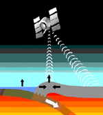
Earthquakes, volcanoes, and mountains are evidence that the Earth massive 7 plates are moving. The theory of plate tectonics tells us that convection currents inside the Earth can affect the crust in certain ways and in different locations. You have seen how plates have moved significantly since Pangaea(used to be a large continent that broke and separated due to geological forces and it formed the 7 continents we know today), how do you think scientists measure the distance that plates move. Scientists now use satellite and laser technology to get the exact distance that plates move, to the nearest centimeter. Laser pulse are shot from the ground to a satellite to reflect an exact location on the ground. New data confirms that parts of the crust are moving from 1 to 12 cm each year. For example the Atlantic ocean is greatly expanding now North America and Europe are being carried further apart due to the expansion of them Atlantic Ocean. Some scientists use conventional ways to read plate movement, they use seismological readings and the information that they get is called seismograph.
